
Audio By Carbonatix
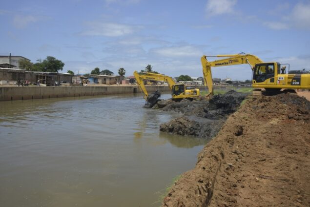
Nearly one-sixth of the legally protected buffer zones along major drainage channels in parts of the Greater Accra Region has been overtaken by unauthorised developments, a new assessment by the Greater Accra Resilient and Integrated Development (GARID) Project has revealed.
The findings come in the wake of the recent devastating floods that displaced thousands of residents and claimed lives in the capital, reinforcing concerns over the impact of uncontrolled development on flood management.
The study, which examined developments within designated drainage corridors across 16 Metropolitan, Municipal and District Assemblies (MMDAs), found that approximately 16 per cent of the mandatory 25-metre drainage buffer zones had been encroached upon.
Presenting the assessment on Friday, July 3, GARID Project Coordinator and member of the Post-Flood Mitigation Committee, Kojo Ohene Safo, explained that the exercise analysed changes in development between 2022 and 2026 using geospatial data and field assessments.
He said the review focused on the legally required 25-metre setback on both sides of major drains, a planning requirement intended to preserve waterways, facilitate maintenance works and reduce flood risks.
According to the assessment, the number of structures erected within protected drainage corridors continues to rise across many parts of the region despite existing planning regulations.
Mr Ohene Safo noted that while some localities recorded little or no additional encroachment, the broader trend points to increasing pressure on drainage infrastructure.
He cited Ablekuma Central as one of the few exceptions, where six structures identified within the protected buffer zone in 2022 remained unchanged during the latest assessment period.
However, he said most of the assemblies studied recorded significant increases in illegal developments.
In Ayawaso Central, structures located within drainage buffers increased from 793 in 2022 to 801 in 2026, while Ayawaso East witnessed a sharper rise from 337 to 494 over the same period.
The situation was similarly pronounced in Ga Central, where an additional 54 structures were erected between 2023 and 2025, raising the total number of encroaching structures within the assessed corridor to 2,329.
Other assemblies also recorded substantial increases.
In Krowor, the number of structures rose from 178 to 295, while Okai Koi North registered an increase from 596 to 729.
Ablekuma West experienced one of the largest jumps, with structures increasing from 904 to 1,293.
The assessment further showed that Ga North recorded a dramatic increase from 1,049 to 2,261 structures, while Ga South rose from 746 to 871.
Encroachment also continued in La Dade-Kotopon, where structures increased from 544 to 638, and Adentan, which rose from 171 to 214.
Mr Ohene Safo disclosed that a total of 10,497 structures were identified within protected drainage buffer zones across the sampled assemblies.
He warned that the growing occupation of waterways was significantly reducing the natural capacity of drains to convey stormwater during periods of intense rainfall.
"And so, when we have the volume of rain that we do, the water doesn’t have a natural path. That will inevitably impact people it will affect them," he stated.
The GARID assessment comes amid renewed national efforts to address flooding following the recent torrential rains that inundated large sections of Accra and other parts of the country.
Urban planning experts have consistently identified encroachment on waterways, indiscriminate construction within drainage reserves, poor waste management and weak enforcement of planning regulations as major contributors to recurrent flooding in the capital.
The findings are expected to inform the work of the government's Post-Flood Mitigation Committee, which is reviewing engineering, planning and enforcement measures aimed at restoring drainage corridors and improving flood resilience across the Greater Accra Region.
Officials have indicated that stronger collaboration between local authorities, planning institutions and enforcement agencies will be required to halt further encroachment and protect critical drainage infrastructure from continued development.
Latest Stories
-
Iran begins public mourning for Ayatollah killed in February
4 minutes -
‘They took their chance; we didn’t’ — Jerome Opoku reflects on Ghana’s World Cup exit
40 minutes -
Lyrical Joe inspires resilience on new single ‘Free Minds’ featuring King Paluta
52 minutes -
Black Stars need time to adapt to Queiroz’s philosophy — Jordan Ayew
2 hours -
Black Stars lost organisation after Senaya’s injury – Carlos Queiroz
2 hours -
Ghana’s World Cup dream ends as Arias fires Colombia into last 16
3 hours -
NDC signs cooperation accord with Russia’s United Russia Party
3 hours -
Taylor Swift and Travis Kelce wed in NYC in ceremony officiated by Adam Sandler
4 hours -
NDPC discusses proposed Black Star Stadium project with Western Regional Minister
4 hours -
NDPC begins review of planning guidelines to strengthen regional and district development coordination
4 hours -
16% of Accra’s drainage buffer zones lost to encroachment — GARID
4 hours -
Akufo-Addo urges African youth to champion education for continental transformation
5 hours -
Russia looks to students to make up for mounting losses in Ukraine
5 hours -
Argentina survive Cabo Verde scare to book Egypt date
6 hours -
Ati-Zigi, Inaki, Opoku return as Queiroz makes four changes for Colombia clash
6 hours