
Audio By Carbonatix
China and India on Monday agreed to stop sending more troops to their disputed border in the Himalayas, following an escalation in tensions between the two nuclear powers.
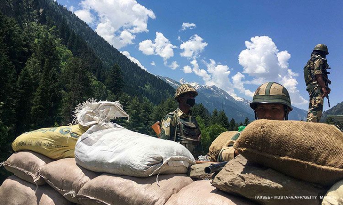
Indian and Chinese senior military commanders met on Monday to discuss stabilizing tensions along the Line of Actual Control (LAC), the loosely defined demarcation line that separates the two countries.
In a joint statement, both sides agreed to strengthen communication on the ground to avoid misunderstandings or action "that may complicate the situation."
They also agreed to not take any unilateral action that would change the situation on the ground, according to the statement. Another round of high-level military meetings will be held "as soon as possible," the statement said.
Tensions have been rising in the Himalayas since a bloody clash between Indian and Chinese troops in June and efforts to deescalate in the wake of the violence appeared to be faltering.
At least 20 Indian soldiers were killed in that incident, the deadliest border conflict with China in over 40 years. China has never acknowledged any casualties from that clash.
Meetings were immediately set up between top Chinese and Indian military officials, and both sides called for calm, but in early September both New Delhi and Beijing accused each other of illegally crossing into their territories, leading to a renewed bout of saber-rattling on both sides.
A week later, China and India accused each other's troops of firing warning shots across the Sino-Indian border, reportedly the first such case in more than four decades. Both sides blamed the other for violating bilateral agreements and taking "provocative" actions.
India and China share a 2,100 mile-long (3,379-kilometer) border in the Himalayas, but both sides claim territory either side of it.
The most recent dispute was around Pangong Tso, a strategically located lake some 14,000 feet (4,200 meters) above sea level that spans an area stretching from the Indian territory of Ladakh to Chinese-controlled Tibet, in the greater Kashmir region, where India, China and Pakistan all claim territory.
The Line of Actual Control, which marks the de facto border and passes through the lake, was established in the wake of the 1962 Sino-Indian war.
Though it shows up on maps, India and China do not agree on its precise location and both regularly accuse the other of overstepping it, or seeking to expand their territory.
In 1996, the two countries signed an agreement which states that neither side shall open fire within 2 kilometers (1.24 miles) from the LAC to "prevent dangerous military activities."
Latest Stories
-
‘No one is above the law’- Volta Chiefs condemn EOCO over handling of Council of State member case
34 seconds -
AMA creates alternative pedestrian routes at Kaneshie after footbridge closure
4 minutes -
Ghanaians were misled- NPP accuses NDC of politicising Anti-LGBTQ bill
5 minutes -
Photos: Mahama receives full state welcome in Paris ahead of talks with French President Macron
26 minutes -
Deputy Health Minister endorses Women in Medicine Fellowship
27 minutes -
Duncan Amoah pushes for Consumer Protection Bill amid VIP fare hike
39 minutes -
LMWG backs Damang lease award to E&P, demands transparency and results
44 minutes -
Volta Chiefs condemns EOCO over alleged disregard for court ruling in Council of State member case
45 minutes -
Matthew Perry’s stepmother says ‘Ketamine Queen’ should get maximum sentence
45 minutes -
Northern Regional Police Command intensifies anti-drug operations, arrests 217 suspects
46 minutes -
The architect of a healthier Ghana: Mahama’s vision and legacy in primary healthcare
48 minutes -
Israel carries out large wave of air strikes across Lebanon
54 minutes -
BBC upholds complaints over racial slur in Baftas broadcast
54 minutes -
Kukurantumi set to host 2025/26 Women’s FA Cup Final as Hasaacas Ladies face Army Ladies
55 minutes -
Where the law stops: Torture, power, and the failure of prevention in Ghana
55 minutes