
Audio By Carbonatix
Tullow Ghana, together with its partners, has commenced a 4D seismic survey across the Jubilee and TEN fields, in a significant step towards enhancing its drilling activities for this year and beyond.
The survey, which began earlier this month, is set to run for approximately 45 days, concluding in early March 2025.
The survey will aim to identify the optimal areas for Tullow's next drilling campaign, ensuring sustainable and efficient resource development.
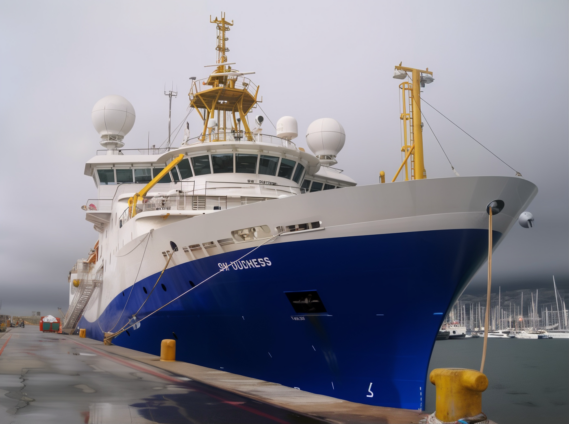
The programme is spearheaded by Norwegian firm Shearwater GeoServices, renowned for its expertise in marine seismic operations.
Shearwater’s advanced vessel, the SW Duchess, is equipped with cutting-edge technology and backed by decades of operational excellence, making it the perfect choice for this complex task.
In a demonstration of local collaboration, the survey is being carried out in partnership with Ghanaian company Destra Energy.
This partnership underscores Tullow Ghana’s commitment to creating opportunities for local participation in the oil and gas value chain.
Recognizing the importance of community involvement, Tullow Ghana and its partners conducted extensive stakeholder engagements before launching the survey.
Meetings were held with key stakeholders, including the Petroleum Commission, representatives from the Canoe Council, the Ghana Navy, the Ghana Marine Authority, local contractors, and other key groups to ensure smooth operations and address potential concerns.
A particular focus was placed on engaging fishing communities along the affected areas to raise awareness about the survey’s activities.
This proactive approach was designed to prevent any interference with fishing canoes and protect marine wildlife, safety and the environment.
Tullow Ghana Managing Director, Jean-Medard Madama said, “We are excited to embark on this programme ahead of our next drilling campaign.
"It will be the first 4D seismic campaign in Ghana's waters and is expected to generate significant data information and insights that will prove crucial for planning efficient drilling operations and maximising resource recovery.
"We have also taken care to engage all relevant stakeholders in line with our commitment to safety and sustainability to ensure maximum success in the seismic campaign in Ghana.”
A 4D seismic survey is a sophisticated technique used by energy companies to gain a detailed understanding of reservoirs beneath the seabed.
It seeks to capture high-resolution images to help pinpoint areas rich in oil and gas to aid operational works offshore.
Latest Stories
-
Trump’s Strait of Hormuz blockade threat raises risks and leaves predicaments unchanged
1 minute -
US Court backs extradiction of former MASLOC CEO Sedina Tamakloe-Attionu’s to Ghana
20 minutes -
Seven arrested as NAIMOS dismantles illegal mining camp, seizes firearms at Boin River
22 minutes -
Fire erupts at Madina Ritz Junction, destroys multiple wooden structures and containers
36 minutes -
Daniel-Kofi Kyereh returns from long-term injury, registers assist for Freiburg U23
48 minutes -
Knifeman calling himself ‘Lucifer’ slashes three at NYC’s Grand Central
1 hour -
Brands are built from within to without
1 hour -
Matriculants urged to pursue excellence as gov’t reaffirms support for Maritime education
1 hour -
See the areas that will be affected by ECG’s planned maintenance on Monday, April 13, 2026
1 hour -
GPL 2025/26: Salim Adams double fires Medeama back to summit after Kotoko rout
1 hour -
Two robbery suspects convicted following violent gold dealer attack in Obuasi
1 hour -
Supreme Court @150: Fanfare meets reflection as nationwide activities roll out
1 hour -
Padel for Parkinson’s cycling event promotes awareness at University of Ghana
2 hours -
GPL 2025/26: Samuel Tetteh brace fires Nations FC past Basake Holy Stars
2 hours -
Ghana’s oil trade position close to net neutral in near term – Fitch
2 hours