
Audio By Carbonatix
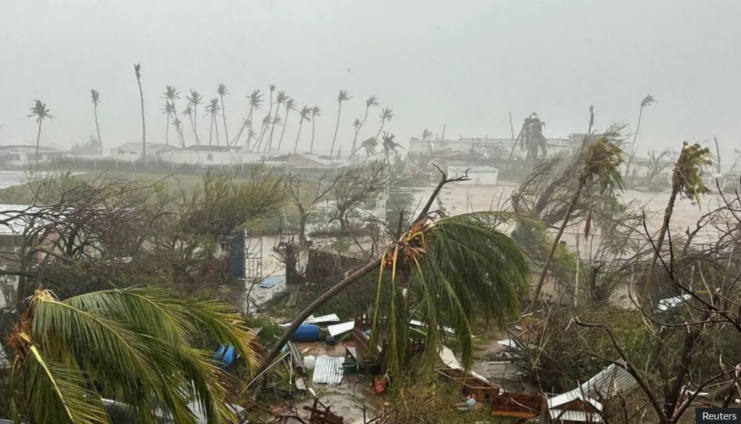
Hurricane Beryl is wreaking havoc in parts of the Caribbean – and putting the role of climate change under the spotlight.
With maximum sustained wind speeds of more than 160mph (257km/h), it became the earliest category five Atlantic hurricane in records going back around 100 years.
In fact, there has only been one previously recorded case of a category five Atlantic hurricane in July – Hurricane Emily, on 16 July 2005.
The causes of individual storms are complex, making it difficult to fully attribute specific cases to climate change.
But exceptionally high sea surface temperatures are seen as a key reason why Hurricane Beryl has been so powerful.
Usually, such strong storms only develop later in the season, after the seas have heated up through the summer.
Hurricanes generally need the sea surface to be at least 27C in order to have a chance of developing. As the map below shows, waters along Hurricane Beryl’s path have been exceptionally warm for this early in the season.
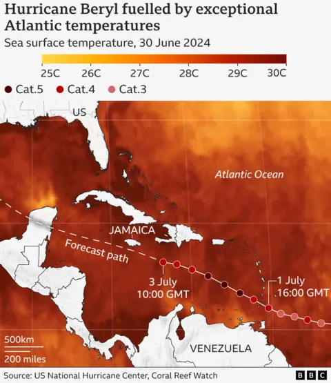
All else being equal, warmer seas mean more powerful hurricanes, because the storms can pick up more energy, enabling higher wind speeds.
“We know that as we warm the planet, we’re warming our sea surface temperatures as well,” explains Andra Garner, an assistant professor at Rowan University in the US.
"And we know that those warm ocean waters are a critical fuel source for hurricanes."
In the main Atlantic hurricane development region, the ocean heat content – the energy stored throughout the water column - is at levels not usually seen until September.
That is when the Atlantic hurricane season is usually at its most active, as the sea surface is typically at its warmest at the end of summer.
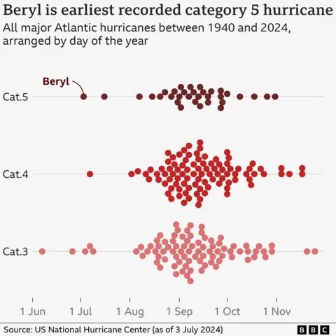
This is illustrated by the chart below, where a dot represents a major hurricane between 1940 and 2024. As you can see, most major hurricanes happen in late August and September, and earlier ones are very rare.
While a category five hurricane is unheard of this early in the season, its strength fits into the broader picture of how these storms are changing in a warming world.
The number of hurricanes has not been increasing, but a higher proportion of them are expected to reach the highest categories globally as temperatures rise.
“Although it is uncertain to what extent climate change contributed to the early formation of Hurricane Beryl, our climate models suggest that the mean intensity of hurricanes will increase in the future due to enhanced global warming,” explains Hiroyuki Murakami, research scientist at Noaa’s Geophysical Fluid Dynamics Laboratory.
Another factor to consider this year is regional weather patterns.
In the eastern Pacific, El Niño conditions have recently come to an end.
El Niño inhibits the formation of strong hurricanes in the Atlantic, because of the way it affects winds in the atmosphere. The opposite phase, known as La Niña, favours Atlantic hurricane development.
Currently, there are “neutral” conditions – neither El Niño nor La Nina. But La Niña conditions are expected later this year.
This likely transition – as well as rising sea temperatures through July and August – has led to concerns that even more powerful hurricanes could form later in the season.
“Hurricane Beryl sets a precedent for what we fear is going to be a very, very active, very dangerous hurricane season, which will impact the entire Atlantic basin,” says Ko Barrett, Deputy Secretary-General of the World Meteorological Organization.
In May, the US weather agency Noaa warned an “extraordinary” Atlantic hurricane season could be in store, forecasting between four and seven major hurricanes – category three (111mph) or above - between June and November. On average, the Atlantic is hit by three major hurricanes a year. Watch: Union Island resident explains impact of Hurricane Beryl
Rapid intensification
Meteorologists and climate scientists have also remarked about how quickly Hurricane Beryl strengthened.
It took just 42 hours to go from a tropical depression – with maximum sustained wind speeds of 38mph or less - to a major hurricane (meaning above 111mph).
“What makes Beryl particularly notable is that it [...] intensified the fastest from a tropical depression to a hurricane [of any Atlantic hurricane in June or early July],” explains Shuyi Chen, professor of atmospheric science at the University of Washington.
Hurricane Beryl is an example of “rapid intensification” - where maximum wind speeds increase very quickly. It can be especially dangerous, because communities have less time to prepare.
The frequency and magnitude of these rapid intensification events in the Atlantic appears to have increased in recent decades.
“Unprecedented as Beryl is, it actually very much aligns with the kinds of extremes we expect in a warmer climate,” Dr Garner says.
“As we’re warming the planet, we’re essentially “stacking the deck” of extreme events against ourselves, making events like Hurricane Beryl not only possible, but more likely.”
“It’s up to us to reduce our emissions to change that story.”
Graphics by Erwan Rivault
Latest Stories
-
Teshie launches Homowo 2026 with renewed commitment to peace, security and cultural heritage
2 hours -
Maritimo target Ghanaian winger Nana Kofi Donkor after impressive season in Georgia
5 hours -
Ghanaian youngster Isaac Assibu signs new Malmo deal, earns first-team promotion
6 hours -
Prince Owusu completes four-year move to DAC 1904
6 hours -
Etihad Airways and Africa World Airlines sign strategic partnership agreement
7 hours -
When Politics Meets Perception: Will Ken Ofori-Atta return to Ghana?
9 hours -
Peace must be the hallmark of Homowo 2026 – DCOP Asiedu
9 hours -
‘Ghana lost a president, but I lost a mentor and a friend’ – Mahama pays tribute to Atta Mills
10 hours -
Ghana’s High Commissioner to UK commits to support Team Ghana at Commonwealth Games
10 hours -
Photos: Flood Mitigation Task Force begins phased dredging, demolition exercise in Accra
11 hours -
ICC top prosecutor removed over sexual misconduct allegations
11 hours -
Glasgow 2026: Ghanaian boxer Abdul Wahid Omar eliminated after unanimous points defeat to Patris Mughalzai
11 hours -
Ghana Gas CEO Judith Adjobah Blay earns Master of Laws degree from University of Nottingham
11 hours -
Gender Minister leads monitoring exercise to strengthen School Feeding Programme
11 hours -
Gov’t advocates capacity building for Ghana’s creative industry at interior design masterclass
11 hours