
Audio By Carbonatix
Over 40 million Americans in parts of at least a dozen states are under a combination of wind and winter weather alerts as a powerful storm pushes east Thursday into the Northern Plains through the Upper Midwest.
Winds are expected to gust up to 65 and 75 mph across the Plains, combining with snow to create blizzard conditions for nearly 2 million people in the Upper Midwest.
The storm already left some 700,000 customers in the Pacific Northwest without power.
Parts of eastern Montana and the Dakotas on Wednesday reported near hurricane-force winds amid springlike warmth.
"The strong winds will usher in more seasonal conditions with temperatures generally in the 30s to low 40s on Thursday," CNN Meteorologist Taylor Ward said.
A slow moving winter storm will bring two days of wintry weather to the Midwest starting tonight. Up to 6 to 10" of snow is forecast across Minnesota and Wisconsin. Strong winds may lead to blizzard conditions, especially across the Dakotas. Light freezing rain is also possible. pic.twitter.com/FynEUDhCzP
— NWS Weather Prediction Center (@NWSWPC) January 13, 2021
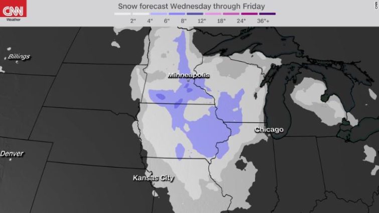
As the storm surges toward the Midwest, cold air behind the system will be greeted by enough moisture to unleash persistent snowfall, gusty winds and periods of blizzard-like conditions in parts of Minnesota, Iowa, Wisconsin and the Eastern Dakotas.
"Travel may become impossible due to winds and zero visibility with the blizzard conditions," CNN Meteorologist Chad Myers warns.
The system is in no rush to move through the region, however, as the impacts could linger well into Friday for millions across the Great Lakes.
Prolonged snowfall, accompanied by periods of heavy lake-effect snow on the south shores of Lake Superior, will lead to widespread coverage of 3 to 6 inches of snow in the Upper Midwest, with the highest totals likely ranging between 6 and 10 inches across Minnesota and northern Wisconsin.
As the system advances eastward Thursday night into Friday, periods of snow, rain and a wintry mix will impact parts Illinois, Indiana, Michigan and Ohio.
Rain and snow reach the Northeast by Friday night
A secondary low pressure system will form along the cold front as the system reaches the East Coast by Friday night into Saturday morning.
While it promises to bring a soggy start to the weekend for the Northeast, the majority of the area will see rain, not snow, thanks to relatively mild January temperatures.
Places like New York City and Boston will be in the mid- to upper 40s Saturday, with a half inch to an inch of rain, as opposed to the several inches of snow they would see if temperatures were colder.
Snowfall Friday night and Saturday will be limited to Upstate New York and northern New England. For the most part, even those locations are only expected to see about 2 to 5 inches, though a few of the favored, higher elevation spots could see over a half a foot of snow.
Launching a balloon in 67 mph winds is not an easy task. If at first you don't succeed, try, try again! After the balloon popped on the first attempt, the second launch went airborne. The radiosonde hit the ground multiple times, but somehow did not fail. #mtwx pic.twitter.com/wtQ6xLZnbD
— NWS Glasgow (@NWSGlasgow) January 13, 2021
The storm earlier in the week gave several cities in the Pacific Northwest the wettest start to any year on record.
And as of early Thursday morning, there were nearly 245,000 customers still without power in Washington, Oregon, Idaho and Montana, according to data from PowerOutages.US.
Generating the storm's powerful winds has been the difference in air pressure between a strong high-pressure zone in the Southwest and the incoming low from the Northwest.
Latest Stories
-
‘It’s not just an inconvenience’: We’ve underestimated the health impacts of heavy periods
14 minutes -
Sonzele Community Bank works to meet BoG’s GH₵5m capital requirement, declares 25.8% dividend
20 minutes -
Bohyen chief appeals for fire station
29 minutes -
Martin Kpebu says legal vacation could delay Wontumi’s bail application
37 minutes -
Duncan Amoah renews call for Ofori-Atta to account for stewardship
52 minutes -
Researchers urged to make academic work useful beyond journals
1 hour -
Unemployed man gets six-month jail term for committing three offences
1 hour -
Chaos mar NDC branch elections in Assin Central Constituency
5 hours -
Wontumi knew he would be convicted – Appiah-Kubi
5 hours -
GIMPA graduates tasks to master modern digital tools to be competitive
5 hours -
Oti High Court adjourns NPP Krachi East Organiser election dispute to October
5 hours -
Court issues bench warrant for man accused of threatening EOCO staff
5 hours -
Vice President Opoku-Agyemang engages Ghanaians in Maryland, United States
5 hours -
UG graduates urged to uphold integrity, excellence
5 hours -
Gabonese President to begin three-day official visit to Ghana on July 28
5 hours