

Audio By Carbonatix
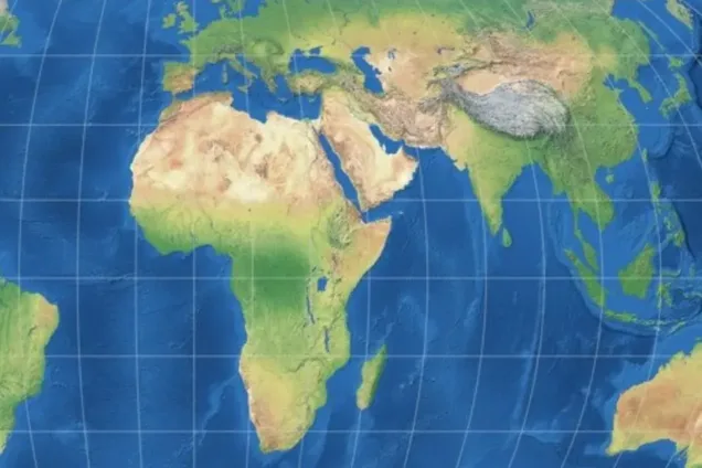
The Ghana Institute of Governance and Security (GIGS) has welcomed the United Nations General Assembly’s adoption of a resolution endorsing the Equal Earth map projection as a fairer alternative to the centuries-old Mercator projection.
GIGS described the resolution as a landmark step towards correcting what it considers more than 450 years of cartographic distortion and restoring Africa’s true geographical scale and significance in the global imagination.
According to the organisation, the resolution was adopted by the UN General Assembly on Friday, September 4, 2026, by 164 votes in favour to one against, with six countries — Estonia, Georgia, Lithuania, Moldova, Serbia and Ukraine — abstaining.
It said the resolution was sponsored by Togo on behalf of the African Union and co-sponsored by the Bahamas, while the United States cast the sole vote against it.
In a statement signed by its Executive Director, Dr David Agbee, GIGS said the development, together with a separate General Assembly resolution recognising the Transatlantic Slave Trade as one of the gravest crimes against humanity, represented two of the most consequential recent steps by the UN in defence of Africa’s dignity.
‘A map is never neutral’
GIGS cited remarks by Togo’s Foreign Minister, Robert Dussey, ahead of the vote that “a fair world begins with a fair map” and that “a map is never neutral.”
The organisation said it fully endorsed that position, arguing that maps play a significant role in shaping perceptions of geography, power and opportunity.
“Maps are not passive renderings of geography — they are instruments of power,” the statement said.
According to GIGS, maps influence how children are taught to perceive the world, how investors assess where opportunities lie, how diplomats assess the weight of different countries and how people understand their own place and that of their continent in global affairs.
It is argued that the visual reduction of Africa on conventional maps had consequences beyond cartography.
“A map that visually diminishes a continent of 1.4 billion people does not merely misinform. It conditions generations to underestimate Africa’s scale, its resources, and its significance,” GIGS said.
Mercator projection
GIGS said the Mercator projection, designed in 1569 primarily as a navigational aid for European sailors, had for more than four and a half centuries been widely presented as an accurate representation of the world despite its distortions.
It explained that the projection enlarges areas closer to the poles, including Europe, North America and Greenland, while reducing the apparent size of regions around the equator, particularly Africa.
The organisation pointed to the size disparity between Africa and Greenland as an illustration of the distortion, noting that Africa is in reality roughly 14 times larger than Greenland even though conventional Mercator maps can make their relative sizes appear much closer.
GIGS said the issue was not merely aesthetic, arguing that the distortion had been reinforced through education, media and technology.
It identified three areas of concern: the visual shrinking of Africa through the continued use of Mercator-style maps; the persistence of colonial-era borders drawn largely in European capitals without sufficient regard for ethnic, cultural and historical realities; and the continued use of outdated map projections in digital maps, search engines and educational software.
It said these practices had helped carry what it described as a colonial-era bias into modern technological platforms.
“Correcting the map is therefore not a symbolic gesture,” GIGS said, describing the UN resolution as “one deliberate step toward correcting the broader architecture of perception that has long under-represented Africa’s true scale and standing in the world.”
GIGS hails overwhelming UN support
GIGS said the 164 votes in favour reflected what it described as a growing international consensus that historical injustices embedded in everyday tools should be deliberately corrected.
The organisation also noted that France had announced ahead of the vote that it would abandon the Mercator projection in its own official maps, describing the move as a sign that the issue was of global relevance and not solely an African concern.
GIGS, however, acknowledged that the UN resolution is not legally binding and does not prohibit the continued use of the Mercator projection for technical purposes for which it remains useful, including maritime and aerial navigation.
Instead, it said, the resolution represents a normative shift by encouraging governments, schools, media organisations, international institutions and technology companies to adopt equal-area projections such as Equal Earth in contexts where relative size and proportion are particularly important.
The organisation said education and public communication should be among the priority areas for such a transition.
Calls for adoption across Africa
GIGS is calling on Ghanaian and African educational authorities to accelerate the adoption of the Equal Earth projection in school curricula, textbooks and other teaching materials.
It also urged African governments and the African Union to sustain the momentum of the “Correct the Map” campaign and extend the conversation to reforms addressing what it described as the governance legacies of colonial-era borders.
The organisation further called on global technology companies and media organisations to update their default map settings so that the change endorsed by the UN translates into the everyday digital experience of millions of users.
It also appealed to the international community to build on what it described as the “twin resolutions” on the Transatlantic Slave Trade and the world map as part of a broader effort to confront historical injustices.
GIGS expressed gratitude to the UN General Assembly, the Togolese government and Foreign Minister Robert Dussey, the African Union and the Bahamas for their roles in advancing the resolution.
It also acknowledged advocacy organisations, including Africa No Filter and Speak Up Africa, for their campaign efforts.
“A fair world does indeed begin with a fair map,” GIGS said.
It added that Ghana should play its part in ensuring that the change represented by the resolution goes beyond cartographic representation to influence “perception, policy, and practice.”
Latest Stories
-
UNICEF Ghana launches first Children’s Film Festival to amplify children’s voices
1 minute -
Ghana must close gaps that allow drug trafficking – Dr Pelpuo
9 minutes -
Emmanuel Osei: President Mahama, dissolve GFA and save our soul
22 minutes -
Uganda Airlines to launch direct Accra-Entebbe flights from October 27
24 minutes -
Ghana records surge in 2025 tourism receipts as Ahafo Region honors top industry players
26 minutes -
I don’t have an official car, I use my own – Pelpuo
37 minutes -
Maiden Black Star Fashion Week to highlight Ghana’s national fashion platform
37 minutes -
GPRTU has entrusted vehicle inspection responsibility to station masters – GPRTU member
37 minutes -
President Mahama to open housing finance conference in Accra on October 7
45 minutes -
Cocaine probe: Speaker is right in dismissing Minority’s motion of parliamentary inquiry – Dr Pelpuo
45 minutes -
Academic City presents cybersecurity white paper to Communications Minister
46 minutes -
Pelpuo calls for independent commission to oversee Ghana’s public sector remuneration
46 minutes -
Bekwai MP to engage Assembly over traders displaced by market redevelopment
48 minutes -
Accra-Abidjan flight relaunch will boost trade, investment and regional integration – Ambassador Alhassan Abu
50 minutes -
Mahama tasked me to identify initiatives that fit Reset Agenda – Pelpuo
50 minutes